
Engineering
The County Engineering Department works closely with all three county supervisors to:
- Maintain county roads and signage
- Facilitate the 9-1-1 addressing program countywide
- Maintain a county Geographical Information System (GIS) online
- Administer funding for county projects
- Assist local businesses and residents regarding floodplain management and easement issues
- Coordinate/cooperate with state, reservation, and federal departments on a wide range of roads issues
FAQs
How do I get a 911 address?
Complete a 911 application form. You will need your parcel ID number of the property and must have an established driveway or a drawing of your parcel and an “X” where your driveway is going to be. You will need to plan on living on the property/or building (we do not address vacant land). Email, fax, or mail your application to the engineering office. We will call or text you after an address is assigned.
How do I get my road maintained?
The county only maintains designated roads. Roads designated as “N” are not maintained by the county. Please call the road yard for your area or the Engineers office to start a work order for your request.
Saint Johns: 928-337-4903
Round Valley: 928-333-4149
Chambers: 928-688-2745
District I: 928-674-5665
District II: 928-755-3881
Engineering: 928-337-7528
What is a parcel number?
An Assessor’s Parcel Number (APN) is assigned to parcels of real property by the tax assessor of a particular jurisdiction for purposes of identification (e.g., 123-45-678). A letter may follow the number if the property was split or combined previously.
When is my property split going to be done and what is a deed number?
If you are checking on a parcel to see when your parcel will be split or combined, please have your deed number handy to help speed up the process of researching. You’ll find the deed number in the upper right corner of a recorded deed.
How do I find my property in Apache County under GIS/Mapping?
Visit the GIS Mapping page and read and accept the disclaimer. You will then be directed to the mapping system.
How do I get signage for county roads?
Please contact the Engineering department at 928-337-7528.
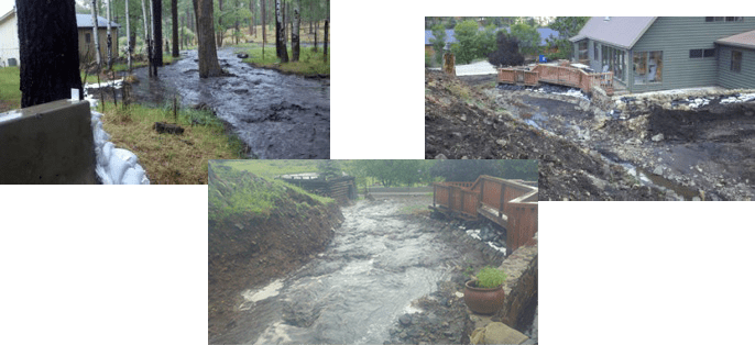
What is a special flood hazard area (floodplain)?
A special flood hazard area is defined as an area having a one percent chance of being inundated by floodwaters in any given year (thus the term “100-year flood plain”).
What are the different zones in a flood hazard area, and what do they mean?
Please refer to the zoning legend for detailed zoning definitions.
Special Flood Hazard Areas (SFHA) – High Risk. These represent the area subject to inundation by the one-percent annual chance flood. Structures located within the SFHA have a 26% chance of flooding during the life of a standard 30-year mortgage. Federal floodplain management regulations and mandatory flood insurance purchase requirements apply in these zones.
Moderate and minimal risk areas – Areas of moderate or minimal hazard are studied based upon the principal source of flood in the area. Buildings in these zones could be flooded by severe, concentrated rainfall coupled with inadequate local drainage systems. Local stormwater drainage systems are not normally considered in a community’s flood insurance study. The failure of a local drainage system can create areas of high flood risk within these zones. Flood insurance is available in participating communities, but not required by regulation in these zones. Nearly 25% of all flood claims filed are for structures located within these zones.
Undetermined risk areas – These include unstudied areas where flood hazards are undetermined but flooding is possible. No mandatory flood insurance purchase requirements apply, but coverage is available in participating communities.
What do I do if I find my property is covered by or has a floodplain on it?
Don’t panic! Review Apache County’s Flood Damage Prevention Ordinance for additional guidelines. If you’ve come to the conclusion that your property is within the boundaries of a flood zone, the first step is to contact our office and verify whether your assumptions are correct. We should be able to confirm or deny whether this is an issue, and if so, you will need to contact an insurance agent to learn how much it will cost you to insure. In most cases, the cost shouldn’t be too outlandish, and luckily, most new home builders aren’t intentionally building properties within the boundaries of a high-risk flood zone (and if they are, they’re probably installing the proper foundation to deal with any potential flood hazards).
Can I build a home within the floodplain?
Please review Apache County’s Flood Damage Prevention Ordinance. All construction allowed in floodplain areas must have the lowest floor elevation at or above the 100-year floodplain elevation. If you have a multi-family or commercial project, you may build in the 100-year floodplain only if your lot complies with all floodplain standards. A FEMA Elevation Certificate is required.
What is an Elevation Certificate?
An Elevation Certificate is an important tool that documents building elevation. If you live in a high-risk flood zone, you should provide an Elevation Certificate to your insurance agent to obtain flood insurance and ensure that your premium accurately reflects your risk. If your home or business is in a high-risk area, your insurance agent will need the Elevation Certificate (EC) to determine your flood insurance premium. The higher your lowest floor is above the Base Flood Elevation (BFE), the lower the risk of flooding.
How do I find if I have access to my property?
We can help. Please provide us with a property tax number or proof of ownership with an appropriate legal location (TN., RG., Sec.). We will then be able to help locate the area in question.
What is a public easement or right-of-way?
A public easement is the right of the general public to use certain streets, highways, or easements.
What is a private easement or right-of-way?
A private right of way is a right given to a particular individual or group of individuals to gain access over a piece of land or property. The underlying land remains private property.
Do you assign addresses for property on the Navajo Nation?
No, we do not. Please contact the Navajo Nation Division of General Services at 928-871-7744.
County Roads Improvement District
For county residents looking for ways to minimize the effects of dust from dirt roads, maintain access to their property in bad weather, or simply improve the appearance of their community, a County Road Improvement District (CRID) may be the answer.
Learn the benefits of and how to form a CRID.
Floodplain Management
For information regarding floodplain maps, please contact our office.
For emergency flood preparedness information, please refer to the flood hazard information provided on this page and visit our Emergency Management page.
You can access and print current floodplain maps from the FEMA Flood Map Service Center. It is helpful to have location coordinates, or you can use the zoom feature to find your location.
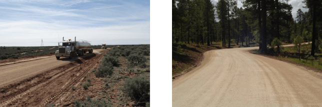
Magnesium Chloride Application
Magnesium chloride controls dust and stabilizes aggregate by acting as a binding agent to provide safer roads and driving conditions, fewer potholes, improved durability, and cleaner air.
Before the county sprays roads with magnesium chloride, we inspect the roads for permeability, smoothness, and proper drainage shaping. If these conditions do not exist, then they must be rectified. The recommended application rate of magnesium chloride is 0.5 gallons per square yard, applied over two applications. This usually provides control and stabilization for two to six months depending on weather and condition of the road base.
Contact Information
Office Hours:
6:30 a.m. to 5:30 p.m.
Monday through Thursday, closed Friday
Apache County Annex Building
75 West Cleveland Street
PO Box 238
St. Johns, AZ 85936
P: 928-337-7528
F: 928-337-2062
Engineering Staff
Forms & Applications
- 911 Address Application
- Abandonment Form 1A
- Abandonment of an Easement Form
- Abandonment Procedures
- Culvert Application
- Engineering Design Standards
- Floodplain Hazard Permit
- Petition for County to Adopt a Road
- Right-of-Way Permit Application
- Right-of-Way Permit Application (for record only)
- Road Complaint Form
- Road Design Standard Variance Request Form
- Roads Standards
- Snow Removal
- Utility Cut Standards
Helpful Information